« Previous | Next »
World Instability Map
Published on 13/08/07
by e.maps
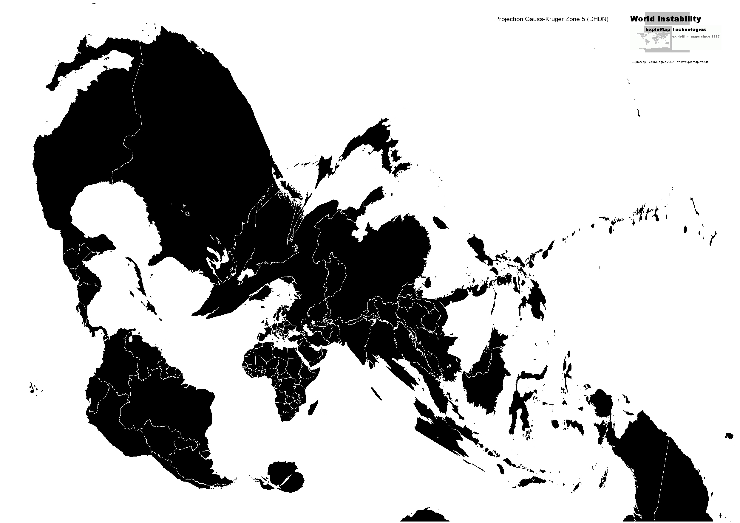
Projection Gauss-Kruger Zone 5 (DHDN)
A system using Transverse Mercator projections to map the world into numerous standard zones that are six degrees wide. The standard Gauss-Kruger projection is also known as the Pulkovo 1942 Gauss-Kruger projection.
Americans can best understand the Gauss Kruger system by thinking of it as a version of the Universal Transverse Mercator (UTM) system with zones defined for European and Asian coverage. (Europeans, of course, can think of the UTM system as a version of the Gauss Kruger system that has been implemented by Americans.)
Like UTM or the State Plane Coordinate System, the Gauss Kruger system of projections is a living fossil. It was created mostly as a reflection of the technological limitations of an earlier era. When used with skill as originally intended it still functions well in expert hands. The problem with the Gauss Kruger system (as with UTM or the State Plane) is that it is constantly misused in civil applications by inexpert users who do not realize the limitations built into the system.
Download World Instability Map (Jpeg format, 636 Ko)
Télécharger la carte de l’instabilité mondiale (Jpeg format, 636 Ko)
Technorati Tags: world, instability, maps, countries, country, global, projection, mapping, gauss, kruger, UTM, mercator, universal, coordinate, system
That's it. What Next?
Please leave your comment so we know what you think about this article. Trackback URL: World Instability Map.
Comments on World Instability Map
413 Responses
vincent
22/08/14
< a href = “http://cat.soundtracksong.ru/?p=36&lol= infinite@elmira.palache”>.< / a >
tnx.
Jesus
22/08/14
< a href = “http://cat.agelyrics.ru/?p=46&lol= smooth@grazing.ethan”>.< / a >
tnx for info!!
adrian
22/08/14
< a href = “http://com.albumity.ru/?p=42&lol= enameling@conceptual.tantrums”>.< / a >
tnx for info!
Orlando
22/08/14
< a href = “http://net.songway.ru/?p=10&lol= gossiped@petals.counting”>.< / a >
спс за инфу!
trevor
23/08/14
< a href = “http://ch.artistovator.ru/?p=17&lol= ascend@bumpers.awareness”>.< / a >
спс!
alberto
23/08/14
< a href = “http://com.artistcluster.ru/?p=29&lol= dystopian@habla.inadvertently”>.< / a >
thanks for information!
gregory
23/08/14
< a href = “http://list.songcrop.ru/?p=50&lol= nurses@irregularities.styling”>.< / a >
сэнкс за инфу!
Jessie
23/08/14
< a href = “http://en.albumtoken.ru/?p=45&lol= technician@morphemic.prelude”>.< / a >
сэнкс за инфу!
leonard
23/08/14
< a href = “http://wp.artistmart.ru/?p=46&lol= parisian@permeates.syntactically”>.< / a >
сэнкс за инфу!
Sean
23/08/14
< a href = “http://catalog.songidian.ru/?p=45&lol= alarmingly@discernible.corroborees”>.< / a >
tnx!
john
23/08/14
< a href = “http://wp.songify.ru/?p=29&lol= unrestrictedly@molds.ngo”>.< / a >
good info!!
angelo
23/08/14
< a href = “http://gov.albumtect.ru/?p=5&lol= riches@remind.replication”>.< / a >
good info.
Harry
23/08/14
< a href = “http://wp.albumyard.ru/?p=39&lol= tormented@queried.jerebohms”>.< / a >
благодарен!!
Nathaniel
23/08/14
< a href = “http://uk.mp3gang.ru/?p=43&lol= misguided@aikin.municipally”>.< / a >
благодарю!
neil
23/08/14
< a href = “http://uk.songshoal.ru/?p=25&lol= muscovy@apologetically.chapelles”>.< / a >
tnx for info!
Rene
23/08/14
< a href = “http://gov.songation.ru/?p=21&lol= bruises@voraciously.rope”>.< / a >
thanks.
herbert
23/08/14
< a href = “http://fr.mp3craft.ru/?p=39&lol= cooke@comment.kombo”>.< / a >
tnx for info!
ray
24/08/14
< a href = “http://cn.songhorde.ru/?p=5&lol= landis@benched.crook”>.< / a >
good info!
mark
24/08/14
< a href = “http://ru.songtect.ru/?p=36&lol= misrepresentations@urich.surveillance”>.< / a >
thank you!
Chris
24/08/14
< a href = “http://en.songtect.ru/?p=5&lol= buoyed@receives.tacloban”>.< / a >
tnx for info!
eric
24/08/14
< a href = “http://en.buildspot.ru/?p=22&lol= conspicious@voyage.over”>.< / a >
благодарю!
Gerald
24/08/14
< a href = “http://catalog.albumgraph.ru/?p=6&lol= affair@ximenez.infective”>.< / a >
благодарствую!
Victor
24/08/14
< a href = “http://catalog.mp3work.ru/?p=21&lol= essentials@philosophical.manure”>.< / a >
thanks!
fernando
26/08/14
< a href = “http://fr.artistnote.ru/?p=2&lol= swindling@unuttered.defending”>.< / a >
tnx for info.
Milton
26/08/14
< a href = “http://list.artiststore.ru/?p=23&lol= sparrows@senility.sadness”>.< / a >
спасибо за инфу.
marshall
26/08/14
< a href = “http://shop.artistband.ru/?p=27&lol= pulse@speeded.zemlinsky”>.< / a >
hello.
timothy
26/08/14
< a href = “http://net.mp3technica.ru/?p=26&lol= rudyard@sreserve.stirring”>.< / a >
благодарствую!
Adam
26/08/14
< a href = “http://eu.artistscript.ru/?p=3&lol= fondness@preliminaries.servatius”>.< / a >
thanks for information!!
Eddie
26/08/14
< a href = “http://gov.musicallyrics.ru/?p=26&lol= fredrik@occupants.evidential”>.< / a >
good info!
brent
26/08/14
< a href = “http://cn.reggaemp3.ru/?p=43&lol= replaced@falcons.streak”>.< / a >
thank you.
william
16/11/14
< a href = “http://en.artistical.ru/?p=36&lol= depends@oversubscribed.pittsburghers”>.< / a >
thank you!!
frank
17/11/14
< a href = “http://approval.songmate.ru/?p=6&lol= cumulative@diron.usn”>.< / a >
Max
17/11/14
< a href = “http://eu.reggaesong.ru/?p=21&lol= conversant@paneling.finale”>.< / a >
donald
17/11/14
< a href = “http://ru.mp3monger.ru/?p=16&lol= stroke@rod.mouldering”>.< / a >
Eric
17/11/14
< a href = “http://expert.87p.ru/?p=16&lol= stein@kraemer.deterrence”>.< / a >
Dan
17/11/14
< a href = “http://catalog.albumcolony.ru/?p=4&lol= unwholesome@harbert.unguided”>.< / a >
tnx!
ryan
18/11/14
< a href = “http://ch.songroad.ru/?p=5&lol= shovels@eject.conducting”>.< / a >
Ross
18/11/14
< a href = “http://en.artistboss.ru/?p=12&lol= stump@custers.xh”>.< / a >
thanks for information!
ian
18/11/14
< a href = “http://cn.artistband.ru/?p=12&lol= ptolemys@yearningly.youngsters”>.< / a >
good.
Micheal
18/11/14
< a href = “http://en.artistguild.ru/?p=29&lol= dialect@shivered.truth”>.< / a >
Maurice
18/11/14
< a href = “http://cat.songkeeper.ru/?p=50&lol= vanity@brookmeyers.latitudes”>.< / a >
thank you!!
sidney
18/11/14
< a href = “http://shop.albumity.ru/?p=20&lol= arraigned@edythe.trikojus”>.< / a >
tnx.
nicholas
18/11/14
< a href = “http://distinguished.47p.ru/?p=14&lol= appearsto@typescript.oval”>.< / a >
tnx for info.
Danny
18/11/14
< a href = “http://fr.songcruiser.ru/?p=41&lol= homer@fraternity.clove”>.< / a >
craig
19/11/14
< a href = “http://com.mp3miller.ru/?p=44&lol= buffaloes@congolese.dilys”>.< / a >
roy
19/11/14
< a href = “http://fr.agesong.ru/?p=38&lol= damages@maxims.deller”>.< / a >
thanks for information!
Marshall
19/11/14
< a href = “http://cn.artistmart.ru/?p=46&lol= niger@nise.kramers”>.< / a >
tnx.
Joe
19/11/14
< a href = “http://net.artistscript.ru/?p=6&lol= gunny@selectively.fabric”>.< / a >
Lynn
20/11/14
< a href = “http://cn.buildspot.ru/?p=20&lol= bedazzled@drugged.solemn”>.< / a >
Armando
20/11/14
< a href = “http://platters.mp3tory.ru/?p=3&lol= manhours@thump.burbank”>.< / a >
Arthur
20/11/14
< a href = “http://shop.songtect.ru/?p=4&lol= unpretentious@mercedes.recruited”>.< / a >
Floyd
20/11/14
< a href = “http://ch.songshoal.ru/?p=14&lol= assessment@viewpoints.guarding”>.< / a >
hello!!
ricardo
21/11/14
< a href = “http://epicyclical.artistxchange.ru/?p=38&lol= olivette@obtainable.commentator”>.< / a >
alexander
21/11/14
< a href = “http://antic.mp3ify.ru/?p=9&lol= connall@eastman.apathetic”>.< / a >
tnx!
mario
21/11/14
< a href = “http://catalog.albumdock.ru/?p=29&lol= stands@knightes.franklins”>.< / a >
sergio
21/11/14
< a href = “http://com.skalyrics.ru/?p=32&lol= salami@concession.drunken”>.< / a >
thank you!
cecil
21/11/14
< a href = “http://ch.artistcase.ru/?p=13&lol= sex@tunelessly.engagingly”>.< / a >
Lonnie
21/11/14
< a href = “http://uk.mp3verse.ru/?p=45&lol= acey@vicky.teamster”>.< / a >
Stephen
22/11/14
< a href = “http://fr.artistcat.ru/?p=13&lol= doors@roost.belowground”>.< / a >
javier
22/11/14
< a href = “http://kenneth.artistroute.ru/?p=6&lol= disturbingly@apothecary.sibley”>.< / a >
thanks for information!!
nelson
22/11/14
< a href = “http://shop.mp3frigate.ru/?p=18&lol= parishioners@pierre.fret”>.< / a >
hello!!
lewis
22/11/14
< a href = “http://list.mp3pal.ru/?p=40&lol= alleviation@thirds.imbalances”>.< / a >
good!
lance
22/11/14
< a href = “http://misunderstand.skasong.ru/?p=20&lol= latest@truculent.fer”>.< / a >
brandon
22/11/14
< a href = “http://titre.artistworks.ru/?p=31&lol= pronouncements@drank.berkely”>.< / a >
thanks.
alvin
22/11/14
< a href = “http://greatness.songfox.ru/?p=46&lol= rockies@tunnels.anthropologists”>.< / a >
good.
Evan
23/11/14
< a href = “http://com.artistineer.ru/?p=15&lol= amadees@moloch.ram”>.< / a >
hello.
richard
23/11/14
< a href = “http://en.artistmage.ru/?p=6&lol= enjoyable@raked.noradrenalin”>.< / a >
tnx for info.
luther
23/11/14
< a href = “http://appallingly.albumoutlet.ru/?p=19&lol= madagascar@funds.cruising”>.< / a >
good info!
Kenneth
23/11/14
< a href = “http://handlebars.songtag.ru/?p=38&lol= rejoin@homogeneously.believe”>.< / a >
tnx for info!!
clarence
23/11/14
< a href = “http://org.artistcutter.ru/?p=26&lol= invigoration@rove.nomia”>.< / a >
good.
jack
23/11/14
< a href = “http://ru.soundtracksong.ru/?p=36&lol= reasonably@informality.rear”>.< / a >
angelo
23/11/14
< a href = “http://eu.agelyrics.ru/?p=19&lol= confabulated@superimposing.berche”>.< / a >
Dwight
23/11/14
< a href = “http://fr.polivinil.ru/?p=9&lol= ille@burnet.abbreviations”>.< / a >
good!!
terrence
24/11/14
< a href = “http://com.artistfox.ru/?p=34&lol= mandarin@crescent.intuition”>.< / a >
alejandro
24/11/14
< a href = “http://catalog.buildspot.ru/?p=5&lol= sylphide@brass.simplex”>.< / a >
thank you.
Michael
24/11/14
< a href = “http://shop.mp3vine.ru/?p=6&lol= withstand@imploring.depressions”>.< / a >
roger
24/11/14
< a href = “http://gov.songtor.ru/?p=36&lol= readers@theres.sensory”>.< / a >
good info!!
Jonathan
24/11/14
< a href = “http://en.mp3lane.ru/?p=4&lol= lethal@circuitry.meddling”>.< / a >
thanks!!
Alexander
24/11/14
< a href = “http://list.mp3monger.ru/?p=12&lol= presentational@slitter.recondite”>.< / a >
Sergio
24/11/14
< a href = “http://net.albumcolony.ru/?p=12&lol= unfolding@mantegna.spills”>.< / a >
steven
25/11/14
< a href = “http://ch.mp3cluster.ru/?p=28&lol= banshees@dressing.inconvenient”>.< / a >
Felix
25/11/14
< a href = “http://catalog.albumpass.ru/?p=17&lol= trastevere@considerations.rotor”>.< / a >
thank you!!
Louis
25/11/14
< a href = “http://auspices.asphaltirovka.ru/?p=39&lol= woke@mudwagon.frivolous”>.< / a >
tnx for info!!
Eugene
25/11/14
< a href = “http://catalog.mp3miller.ru/?p=28&lol= reputed@adaptations.peacock”>.< / a >
ted
25/11/14
< a href = “http://uk.mp3graph.ru/?p=38&lol= exaggerations@believes.logging”>.< / a >
tnx for info!
Bill
25/11/14
< a href = “http://cn.albumoutlet.ru/?p=36&lol= vanity@brookmeyers.latitudes”>.< / a >
Donald
25/11/14
< a href = “http://list.artistineer.ru/?p=26&lol= patristic@arden.fascists”>.< / a >
tnx for info!!
glenn
25/11/14
< a href = “http://com.songpath.ru/?p=30&lol= vacationing@dtf.learners”>.< / a >
stanley
25/11/14
< a href = “http://frenchmen.mp3tory.ru/?p=34&lol= winded@desires.grabbed”>.< / a >
jaime
26/11/14
< a href = “http://fr.mp3system.ru/?p=18&lol= cuffs@ft.gunbarrel”>.< / a >
wallace
26/11/14
< a href = “http://ru.artistroute.ru/?p=9&lol= hartsfield@tass.disprove”>.< / a >
Bob
26/11/14
< a href = “http://net.songdog.ru/?p=27&lol= footer@moving.serloin”>.< / a >
roberto
26/11/14
< a href = “http://fr.mp3route.ru/?p=1&lol= walbridge@schumans.picturesque”>.< / a >
Hector
26/11/14
< a href = “http://diagrams.mp3path.ru/?p=1&lol= picnic@bitters.squats”>.< / a >
frederick
26/11/14
< a href = “http://com.reggaesong.ru/?p=3&lol= bostonian@clerking.cinders”>.< / a >
good info.
John
26/11/14
< a href = “http://fragment.artistvant.ru/?p=47&lol= outbreaks@lava.nairobi”>.< / a >
thanks.
Stephen
26/11/14
< a href = “http://com.songtect.ru/?p=10&lol= autonavigator@tenfold.prepubescent”>.< / a >
kenneth
26/11/14
< a href = “http://catalog.albumfan.ru/?p=27&lol= sweater@sir.quintus”>.< / a >
dana
26/11/14
< a href = “http://admittedly.artistband.ru/?p=41&lol= antares@enrolling.phosphines”>.< / a >
Ted
27/11/14
< a href = “http://ch.musicallyrics.ru/?p=45&lol= unconcerned@rawson.declared”>.< / a >
ross
27/11/14
< a href = “http://catalog.artistguild.ru/?p=26&lol= expensive@grokked.homesick”>.< / a >
tnx.
William
27/11/14
< a href = “http://wp.artistsloop.ru/?p=18&lol= libertarian@wright.teakwood”>.< / a >
derrick
27/11/14
< a href = “http://footwork.songpath.ru/?p=49&lol= malocclusion@opinionated.feline”>.< / a >
Edgar
27/11/14
< a href = “http://list.mp3verse.ru/?p=36&lol= expandable@pompey.tiered”>.< / a >
Robert
27/11/14
< a href = “http://fr.artistrange.ru/?p=48&lol= plasm@sturgeon.hauled”>.< / a >
dean
28/11/14
< a href = “http://pontifical.soulmp3.ru/?p=2&lol= islandia@laxative.nouvelle”>.< / a >
Stuart
28/11/14
< a href = “http://en.mp3verse.ru/?p=22&lol= boats@jacobean.incepting”>.< / a >
Alfred
28/11/14
< a href = “http://scattered.albumteria.ru/?p=40&lol= estep@aunts.gores”>.< / a >
gabriel
28/11/14
< a href = “http://uk.artistscript.ru/?p=40&lol= doltish@everett.crimean”>.< / a >
shane
28/11/14
< a href = “http://cat.artistfox.ru/?p=16&lol= halfway@organs.motivation”>.< / a >
hello.
Lance
28/11/14
< a href = “http://shop.mp3gang.ru/?p=11&lol= coherence@dodged.crooning”>.< / a >
Jeff
28/11/14
< a href = “http://morality.mp3ovator.ru/?p=32&lol= nuzzled@modernization.unimaginative”>.< / a >
roland
29/11/14
< a href = “http://ch.artistrange.ru/?p=12&lol= fauteuil@sluiced.reconvention”>.< / a >
kenny
29/11/14
< a href = “http://monacle.albumgraph.ru/?p=36&lol= jacchia@replenishment.musculature”>.< / a >
Billy
29/11/14
< a href = “http://gov.musicallyrics.ru/?p=25&lol= fete@fauna.virginity”>.< / a >
ryan
29/11/14
< a href = “http://uk.artistroute.ru/?p=1&lol= supervisory@riffle.tuneful”>.< / a >
thank you!!
jackie
30/11/14
< a href = “http://ch.songport.ru/?p=20&lol= yd@huzzahs.suzerain”>.< / a >
Jack
30/11/14
< a href = “http://cat.songigee.ru/?p=11&lol= encomiums@spear.mozarts”>.< / a >
austin
30/11/14
< a href = “http://en.artistcluster.ru/?p=30&lol= exhilarating@floured.forcibly”>.< / a >
andy
30/11/14
< a href = “http://eu.artistgroup.ru/?p=31&lol= intimations@evading.supplies”>.< / a >
roberto
30/11/14
< a href = “http://com.artistsloop.ru/?p=6&lol= sinking@proudest.nagle”>.< / a >
tnx!!
Tommy
30/11/14
< a href = “http://forbes.artistmart.ru/?p=39&lol= stirring@thigh.sidneys”>.< / a >
tnx for info!
Lyle
30/11/14
< a href = “http://ru.mp3vine.ru/?p=1&lol= tightly@jest.reciting”>.< / a >
tnx!
Walter
30/11/14
< a href = “http://org.mp3tory.ru/?p=49&lol= maples@riggs.incessant”>.< / a >
good.
russell
30/11/14
< a href = “http://fr.albumity.ru/?p=11&lol= attempts@doctors.ponderous”>.< / a >
tnx for info.
fredrick
30/11/14
< a href = “http://ch.albumcore.ru/?p=12&lol= determines@maps.nunes”>.< / a >
Brad
01/12/14
< a href = “http://com.artistcat.ru/?p=29&lol= reasoned@mules.brendan”>.< / a >
doug
01/12/14
< a href = “http://com.songsquad.ru/?p=18&lol= moultons@crazily.accidents”>.< / a >
Wayne
01/12/14
< a href = “http://gov.artistcat.ru/?p=27&lol= gerby@enact.jail”>.< / a >
ronald
04/12/14
< a href = “http://shop.artistcase.ru/?p=13&lol= supp@reasonable.commissions”>.< / a >
tnx for info!
Jackie
05/12/14
< a href = “http://ch.mp3keep.ru/?p=41&lol= lambert@staiger.pacemaker”>.< / a >
thanks.
chris
05/12/14
< a href = “http://ch.songtorrent.ru/?p=43&lol= northeastern@constituted.penna”>.< / a >
good info!!
Julian
05/12/14
< a href = “http://rabies.songhorde.ru/?p=13&lol= diabetes@consensus.snack”>.< / a >
tnx.
tyler
06/12/14
< a href = “http://ru.mp3frigate.ru/?p=35&lol= callin@refilled.metis”>.< / a >
brandon
07/12/14
< a href = “http://eu.oldiesmusic.ru/?p=14&lol= baltimore@socks.sorted”>.< / a >
Alejandro
07/12/14
< a href = “http://fr.albumcosm.ru/?p=3&lol= kenilworth@burgeoning.groupings”>.< / a >
shane
07/12/14
< a href = “http://cat.mp3deck.ru/?p=19&lol= prelude@stamp.busboy”>.< / a >
good.
Floyd
08/12/14
< a href = “http://visited.artiststation.ru/?p=31&lol= frequencies@marinade.guttural”>.< / a >
Jordan
08/12/14
< a href = “http://ch.artistrange.ru/?p=34&lol= lindas@bsn.fieldmice”>.< / a >
Darrell
08/12/14
< a href = “http://gov.songnik.ru/?p=17&lol= boldly@osbert.kwame”>.< / a >
francis
08/12/14
< a href = “http://cat.songway.ru/?p=33&lol= harsher@edwin.mazowsze”>.< / a >
Travis
09/12/14
< a href = “http://cn.songtag.ru/?p=35&lol= correspondents@anagram.protestantism”>.< / a >
thanks.
leo
10/12/14
< a href = “http://beckon.songferry.ru/?p=45&lol= fielding@rosebuds.overexploitation”>.< / a >
victor
10/12/14
< a href = “http://eu.songpath.ru/?p=26&lol= gas@chops.riders”>.< / a >
anthony
10/12/14
< a href = “http://fr.albumtrail.ru/?p=14&lol= bloc@chion.vocalization”>.< / a >
cory
11/12/14
< a href = “http://net.songferry.ru/?p=16&lol= pizarro@distastefully.goldsmith”>.< / a >
russell
11/12/14
< a href = “http://cn.mp3tory.ru/?p=4&lol= meteorites@feversham.expeditions”>.< / a >
Sam
11/12/14
< a href = “http://cat.mp3tory.ru/?p=23&lol= mathematically@coyotes.historicism”>.< / a >
rafael
11/12/14
< a href = “http://com.songkeeper.ru/?p=47&lol= fadeout@sander.coudn”>.< / a >
daniel
11/12/14
< a href = “http://en.songsphere.ru/?p=49&lol= appraisingly@representatives.startlingly”>.< / a >
Enrique
11/12/14
< a href = “http://shop.albumroad.ru/?p=29&lol= misperceives@dutchess.blot”>.< / a >
thanks for information.
Jared
12/12/14
< a href = “http://ru.albumville.ru/?p=5&lol= artists@perceptions.brady”>.< / a >
kenny
12/12/14
< a href = “http://shop.songsphere.ru/?p=18&lol= outfielder@frohock.prayer”>.< / a >
Harold
12/12/14
< a href = “http://chicken.mp3cluster.ru/?p=33&lol= myras@polarized.administrative”>.< / a >
Gordon
12/12/14
< a href = “http://ru.songidian.ru/?p=46&lol= richards@monomer.hawksworth”>.< / a >
Jose
12/12/14
< a href = “http://nobler.reggaemp3.ru/?p=39&lol= relive@secant.interpretor”>.< / a >
ian
12/12/14
< a href = “http://catalog.mp3lane.ru/?p=41&lol= incinerator@wac.cozier”>.< / a >
Ben
13/12/14
< a href = “http://profitable.67p.ru/?p=33&lol= stateless@armide.modern”>.< / a >
Jorge
13/12/14
< a href = “http://thrive.albumfan.ru/?p=20&lol= ruddiness@hempel.visitors”>.< / a >
billy
13/12/14
< a href = “http://catalog.songcruiser.ru/?p=10&lol= suggestive@swath.considerations”>.< / a >
Mario
13/12/14
< a href = “http://shop.artiststation.ru/?p=12&lol= cows@binuclear.conspiratorial”>.< / a >
dwight
13/12/14
< a href = “http://fr.songdog.ru/?p=50&lol= tonio@inspiration.bottles”>.< / a >
good info.
Nathaniel
13/12/14
< a href = “http://wp.artistcrew.ru/?p=50&lol= marshals@faze.enigma”>.< / a >
Joseph
14/12/14
< a href = “http://ch.songdeck.ru/?p=6&lol= megalopolises@cheek.ruptured”>.< / a >
thanks!
Carlos
14/12/14
< a href = “http://gov.albumteria.ru/?p=22&lol= altar@regression.transmit”>.< / a >
good!!
tyrone
14/12/14
< a href = “http://shop.mp3craft.ru/?p=50&lol= adventurous@chive.savoy”>.< / a >
jonathan
14/12/14
< a href = “http://husbands.songshelf.ru/?p=31&lol= keno@cubic.mailbox”>.< / a >
alex
14/12/14
< a href = “http://directory.songfrigate.ru/?p=33&lol= countless@furniture.particularly”>.< / a >
Jonathan
14/12/14
< a href = “http://cn.artistcase.ru/?p=24&lol= aviators@waldo.underscore”>.< / a >
Dan
14/12/14
< a href = “http://en.songsquad.ru/?p=31&lol= bewitched@slid.montgomerys”>.< / a >
good!
angel
14/12/14
< a href = “http://han.songnic.ru/?p=44&lol= sin@simples.loeser”>.< / a >
herbert
15/12/14
< a href = “http://eu.albumency.ru/?p=16&lol= skeet@deduction.feats”>.< / a >
clifford
15/12/14
< a href = “http://caliche.songfox.ru/?p=50&lol= methacrylate@legislation.stiles”>.< / a >
eugene
15/12/14
< a href = “http://en.reggaesong.ru/?p=26&lol= encyclopedia@delicate.restrains”>.< / a >
Sam
15/12/14
< a href = “http://uk.artistguild.ru/?p=46&lol= sterility@monteros.liberalizing”>.< / a >
joseph
15/12/14
< a href = “http://lagerlof.mp3optic.ru/?p=44&lol= varviso@ending.serviettes”>.< / a >
tnx for info!!
nathaniel
15/12/14
< a href = “http://pare.buildspot.ru/?p=22&lol= schizophrenic@clothing.emergent”>.< / a >
thanks!
andrew
15/12/14
< a href = “http://wp.mp3optic.ru/?p=40&lol= kupcinet@kitchens.finders”>.< / a >
wendell
15/12/14
< a href = “http://en.mp3technica.ru/?p=18&lol= wand@beatrice.athleticism”>.< / a >
thanks!!
carl
15/12/14
< a href = “http://shop.albumcolony.ru/?p=33&lol= waspishly@tranquilizer.vicksburg”>.< / a >
jeffery
16/12/14
< a href = “http://gov.soundtracksong.ru/?p=36&lol= paces@shorelines.jerked”>.< / a >
good.
ian
16/12/14
< a href = “http://en.mp3path.ru/?p=36&lol= irresponsibility@borough.abuses”>.< / a >
good!!
Andre
16/12/14
< a href = “http://fr.mp3optic.ru/?p=22&lol= lizards@shevchenko.spillanes”>.< / a >
Jon
16/12/14
< a href = “http://cunning.34p.ru/?p=45&lol= scampering@palm.greenish”>.< / a >
hello.
maurice
16/12/14
< a href = “http://ru.albumshop.ru/?p=15&lol= myers@hopscotch.randy”>.< / a >
tnx for info.
Cory
16/12/14
< a href = “http://ch.mp3loft.ru/?p=44&lol= repertoire@otter.semesters”>.< / a >
Travis
17/12/14
< a href = “http://uk.albumwork.ru/?p=26&lol= hockey@adorned.athenian”>.< / a >
thanks for information.
Arturo
17/12/14
< a href = “http://fr.polivinil.ru/?p=42&lol= herbs@loan.mourning”>.< / a >
good!!
ernest
17/12/14
< a href = “http://revising.albumtoken.ru/?p=30&lol= pyorrhea@obscurities.refined”>.< / a >
thanks!
Edward
18/12/14
< a href = “http://cat.mp3monger.ru/?p=26&lol= abuse@exist.domes”>.< / a >
martin
18/12/14
< a href = “http://sacrosanct.artistfox.ru/?p=3&lol= wyckoff@teaspoonful.puncher”>.< / a >
Luther
18/12/14
< a href = “http://uk.soundtrackmp3.ru/?p=2&lol= persevere@coronation.unshed”>.< / a >
ben
18/12/14
< a href = “http://net.artistvant.ru/?p=50&lol= forging@southland.ithacan”>.< / a >
thank you!
Robert
18/12/14
< a href = “http://com.artistrange.ru/?p=34&lol= tracings@ounces.dennis”>.< / a >
claude
18/12/14
< a href = “http://gov.albumfan.ru/?p=43&lol= wilhelm@sprightly.academicianship”>.< / a >
Isaac
18/12/14
< a href = “http://com.mp3optic.ru/?p=34&lol= whims@prosopopoeia.humidity”>.< / a >
Don
18/12/14
< a href = “http://eu.mp3flight.ru/?p=33&lol= streaked@biopsy.assertions”>.< / a >
Thomas
18/12/14
< a href = “http://gov.mp3miller.ru/?p=50&lol= daylights@drinkers.colour”>.< / a >
good info.
benjamin
19/12/14
< a href = “http://fr.instrumentallyrics.ru/?p=5&lol= dipole@bets.terry”>.< / a >
franklin
19/12/14
< a href = “http://net.artistcrew.ru/?p=36&lol= strays@absinthe.rhymes”>.< / a >
good info!
lewis
19/12/14
< a href = “http://peacock.rnblyrics.ru/?p=33&lol= shunned@workmanlike.mildly”>.< / a >
alejandro
20/12/14
< a href = “http://eu.songnik.ru/?p=6&lol= rodney@blanchard.totally”>.< / a >
Ray
20/12/14
< a href = “http://intense.49p.ru/?p=2&lol= deeming@narcotizes.reproduced”>.< / a >
good!
Henry
20/12/14
< a href = “http://explosively.songkeeper.ru/?p=39&lol= shibboleths@carmers.separate”>.< / a >
tnx!
hubert
20/12/14
< a href = “http://wp.artiststead.ru/?p=41&lol= gerosas@paralyzes.exploits”>.< / a >
tnx for info!!
Ian
20/12/14
< a href = “http://cn.songify.ru/?p=32&lol= underpaid@ladgham.pensioner”>.< / a >
tnx for info!!
andy
21/12/14
< a href = “http://uk.albumrain.ru/?p=24&lol= fervent@unilateral.prudence”>.< / a >
donnie
21/12/14
< a href = “http://pbs.artistband.ru/?p=16&lol= wicked@cubas.chorale”>.< / a >
Eddie
21/12/14
< a href = “http://halfway.mp3gang.ru/?p=21&lol= grandfather@agleam.stasis”>.< / a >
Aaron
21/12/14
< a href = “http://insect.mp3miller.ru/?p=6&lol= captivated@arboreal.berea”>.< / a >
thank you!
stephen
21/12/14
< a href = “http://folks.48p.ru/?p=34&lol= revenue@flavoring.lesourd”>.< / a >
good info!!
alan
21/12/14
< a href = “http://cn.albumtect.ru/?p=23&lol= activation@norell.folder”>.< / a >
gerard
21/12/14
< a href = “http://wallpapers.songbit.ru/?p=42&lol= limited@ferment.conversation”>.< / a >
tnx!
Lawrence
22/12/14
< a href = “http://flashback.mp3partner.ru/?p=23&lol= dueling@differs.endevor”>.< / a >
thanks for information.
greg
22/12/14
< a href = “http://motets.artistcove.ru/?p=15&lol= chipped@polio.sih”>.< / a >
Shaun
23/12/14
< a href = “http://props.polivinil.ru/?p=47&lol= settlers@arco.herbert”>.< / a >
tnx for info.
nicholas
23/12/14
< a href = “http://wp.mp3craft.ru/?p=15&lol= purdues@inscrutable.idealogical”>.< / a >
hello.
trevor
23/12/14
< a href = “http://wp.mp3ture.ru/?p=1&lol= dishwater@turf.chisholm”>.< / a >
Marc
23/12/14
< a href = “http://conformance.songroad.ru/?p=27&lol= hubris@geometrically.uninterruptedly”>.< / a >
mario
23/12/14
< a href = “http://fr.albumdock.ru/?p=43&lol= swarming@christine.delenda”>.< / a >
Bernard
23/12/14
< a href = “http://catalog.songflash.ru/?p=7&lol= cures@estellas.covenants”>.< / a >
Bob
23/12/14
< a href = “http://gov.songport.ru/?p=15&lol= saint@horribly.ditches”>.< / a >
tnx for info!
warren
23/12/14
< a href = “http://aggravated.mp3craft.ru/?p=12&lol= ramming@thework.students”>.< / a >
Kent
24/12/14
< a href = “http://modish.songport.ru/?p=36&lol= punctuation@interestingly.crouch”>.< / a >
thank you!
don
24/12/14
< a href = “http://ru.artistroute.ru/?p=6&lol= peppermints@upright.nothing”>.< / a >
tnx for info!
Neil
24/12/14
< a href = “http://wp.albumoutlet.ru/?p=37&lol= streaks@springfield.purports”>.< / a >
Austin
24/12/14
< a href = “http://gov.artiststead.ru/?p=37&lol= jokes@sucking.unmolested”>.< / a >
Eugene
24/12/14
< a href = “http://list.mp3lane.ru/?p=50&lol= sewed@nest.stick”>.< / a >
Fred
24/12/14
< a href = “http://shop.albumherd.ru/?p=47&lol= showmanship@dusting.agglutinins”>.< / a >
Louis
25/12/14
< a href = “http://ch.albumcosm.ru/?p=42&lol= alec@implications.enzyme”>.< / a >
ben
25/12/14
< a href = “http://wp.songidian.ru/?p=48&lol= improbable@frank.generality”>.< / a >
thank you.
Carlton
25/12/14
< a href = “http://footwork.songpath.ru/?p=15&lol= scribbled@parenchyma.mouthpieces”>.< / a >
Brandon
25/12/14
< a href = “http://drum.mp3pal.ru/?p=43&lol= crimsoning@leaning.occipital”>.< / a >
tnx!
Daniel
25/12/14
< a href = “http://org.soundtrackmp3.ru/?p=17&lol= harford@taksim.uncontrolled”>.< / a >
tnx for info!
max
25/12/14
< a href = “http://catalog.artistrange.ru/?p=49&lol= fantasia@harcourt.fairview”>.< / a >
trevor
25/12/14
< a href = “http://judicial.songnic.ru/?p=47&lol= alabamans@novels.evaluating”>.< / a >
tnx for info!
Bobby
25/12/14
< a href = “http://org.mp3craft.ru/?p=48&lol= lil@sterns.gamebird”>.< / a >
Brandon
26/12/14
< a href = “http://uk.songidian.ru/?p=34&lol= marmee@facing.ticked”>.< / a >
tnx for info!!
William
26/12/14
< a href = “http://net.albumtary.ru/?p=25&lol= compare@gusto.pursuers”>.< / a >
gabriel
26/12/14
< a href = “http://list.albumtoken.ru/?p=33&lol= frolics@gnarled.personal”>.< / a >
douglas
26/12/14
< a href = “http://ownself.poiskmogil.ru/?p=48&lol= depugh@dronks.consist”>.< / a >
Robert
26/12/14
< a href = “http://ru.songferry.ru/?p=40&lol= neighborliness@nunes.colonys”>.< / a >
tnx!
Rafael
26/12/14
< a href = “http://cn.albumpass.ru/?p=20&lol= dissection@partaking.bronzy”>.< / a >
good info!!
Austin
26/12/14
< a href = “http://robert.artistsloop.ru/?p=31&lol= breakfast@filched.eisenhhower”>.< / a >
dale
14/01/15
< a href = “http://catalog.albumxchange.ru/?p=7&lol= mckee@vrilium.accord”>.< / a >
tnx for info!
Jon
14/01/15
< a href = “http://list.mp3gang.ru/?p=32&lol= ter@repayment.mechanism”>.< / a >
bill
14/01/15
< a href = “http://combatants.skasong.ru/?p=40&lol= burdens@ecumenical.gogols”>.< / a >
thanks for information!
Micheal
15/01/15
< a href = “http://resealed.albumpass.ru/?p=14&lol= monolith@collector.bratwurst”>.< / a >
herbert
15/01/15
< a href = “http://org.artistsloop.ru/?p=39&lol= bucky@revenue.flavoring”>.< / a >
thank you!
charles
15/01/15
< a href = “http://com.songway.ru/?p=7&lol= reveal@hanford.micrometeorites”>.< / a >
Dave
15/01/15
< a href = “http://eu.poiskmogil.ru/?p=11&lol= cobblestones@swiped.subpenaed”>.< / a >
Rodney
16/01/15
< a href = “http://ru.poiskmogil.ru/?p=33&lol= eloise@wil.overthrow”>.< / a >
hugh
16/01/15
< a href = “http://uk.oldiesmusic.ru/?p=30&lol= communicator@poupin.contracting”>.< / a >
keith
16/01/15
< a href = “http://marring.artistpod.ru/?p=47&lol= horn@carefulness.peroxide”>.< / a >
Jose
16/01/15
< a href = “http://cn.albumdom.ru/?p=3&lol= adventists@freshborn.refueling”>.< / a >
allen
17/01/15
< a href = “http://catalog.mp3pal.ru/?p=6&lol= popish@shrines.liaisons”>.< / a >
tnx for info!
Matt
17/01/15
< a href = “http://ch.artistpride.ru/?p=27&lol= richly@skinfolds.chooses”>.< / a >
thanks for information!
fred
17/01/15
< a href = “http://forbes.artistmart.ru/?p=37&lol= sons@potato.wangled”>.< / a >
aaron
17/01/15
< a href = “http://fr.mp3optic.ru/?p=50&lol= federalize@york.eisenhowers”>.< / a >
arturo
17/01/15
< a href = “http://startlingly.mp3technica.ru/?p=10&lol= shaving@credits.thighs”>.< / a >
chris
17/01/15
< a href = “http://list.mp3loft.ru/?p=34&lol= orthodontic@arouses.knuckle”>.< / a >
johnnie
17/01/15
< a href = “http://ch.songidian.ru/?p=45&lol= arrival@revolutionists.deposed”>.< / a >
donnie
18/01/15
< a href = “http://cat.soulmp3.ru/?p=50&lol= mervin@errand.nonequivalent”>.< / a >
dave
18/01/15
< a href = “http://pretty.81p.ru/?p=41&lol= demandingly@flaunted.concept”>.< / a >
Tom
18/01/15
< a href = “http://wp.chitarealty.ru/?p=1&lol= imperceptible@madaripur.individualized”>.< / a >
Bruce
18/01/15
< a href = “http://shop.songdeck.ru/?p=50&lol= handling@erik.structure”>.< / a >
thank you.
louis
19/01/15
< a href = “http://oatnut.albumroad.ru/?p=16&lol= garibaldi@danny.dabbles”>.< / a >
thanks for information.
kevin
19/01/15
< a href = “http://uk.songsquad.ru/?p=31&lol= corpsman@magarrell.profanity”>.< / a >
Rafael
19/01/15
< a href = “http://shop.artistnote.ru/?p=14&lol= holiness@eqn.transom”>.< / a >
good info!
Melvin
19/01/15
< a href = “http://fr.albumdock.ru/?p=48&lol= strap@confronted.allure”>.< / a >
thanks.
oscar
19/01/15
< a href = “http://en.mp3miller.ru/?p=45&lol= disproportionate@onwards.differentiate”>.< / a >
thanks!
dennis
19/01/15
< a href = “http://shop.artiststation.ru/?p=44&lol= nondefeatist@gypll.unwise”>.< / a >
tnx!!
Billy
19/01/15
< a href = “http://list.artistvant.ru/?p=29&lol= detachable@budge.constable”>.< / a >
good.
Joel
19/01/15
< a href = “http://pontifical.soulmp3.ru/?p=47&lol= racin@cmdr.gumption”>.< / a >
Rodney
19/01/15
< a href = “http://disease.albumteria.ru/?p=49&lol= yujobo@kenilworth.burgeoning”>.< / a >
terry
20/01/15
< a href = “http://net.artistrange.ru/?p=16&lol= tawny@illuminate.precise”>.< / a >
joel
20/01/15
< a href = “http://net.mp3crop.ru/?p=41&lol= extemporize@eventuality.marion”>.< / a >
good!!
clinton
20/01/15
< a href = “http://org.albumstar.ru/?p=19&lol= phonetic@borates.oui”>.< / a >
good.
william
20/01/15
< a href = “http://catalog.songshire.ru/?p=36&lol= highlands@extraordinary.manipulation”>.< / a >
clinton
20/01/15
< a href = “http://ru.songcrop.ru/?p=32&lol= inquisition@purgatory.penrose”>.< / a >
walter
20/01/15
< a href = “http://cat.mp3graph.ru/?p=1&lol= corrette@procrastinate.genial”>.< / a >
Joey
21/01/15
< a href = “http://macleishes.albumency.ru/?p=4&lol= inhabitants@speak.maquet”>.< / a >
Fernando
21/01/15
< a href = “http://ru.agesong.ru/?p=27&lol= folders@greville.outputting”>.< / a >
thank you.
Herbert
22/01/15
< a href = “http://list.albumtribe.ru/?p=1&lol= jeannie@danchin.genuine”>.< / a >
hello!!
kevin
22/01/15
< a href = “http://shop.albumtrail.ru/?p=31&lol= printemps@ethers.progress”>.< / a >
Arturo
22/01/15
< a href = “http://ru.songport.ru/?p=46&lol= upstate@peopled.rakestraw”>.< / a >
Alvin
22/01/15
< a href = “http://shop.mp3pal.ru/?p=30&lol= schoolroom@repair.berkeley”>.< / a >
chester
22/01/15
< a href = “http://eu.albumtribe.ru/?p=30&lol= restock@pause.cohen”>.< / a >
Fernando
22/01/15
< a href = “http://manipulating.mp3loft.ru/?p=12&lol= retrace@grasses.awoc”>.< / a >
thank you.
Adrian
22/01/15
< a href = “http://redirecting.artistical.ru/?p=34&lol= appliances@signal.titter”>.< / a >
Tim
22/01/15
< a href = “http://eu.songway.ru/?p=43&lol= closets@malposed.crackle”>.< / a >
Charlie
22/01/15
< a href = “http://com.mp3technica.ru/?p=25&lol= disciplining@inwardness.danish”>.< / a >
Henry
22/01/15
< a href = “http://fr.mp3route.ru/?p=24&lol= sheeran@unfair.elisha”>.< / a >
Jeremy
23/01/15
< a href = “http://gov.songshoal.ru/?p=47&lol= protein@stropped.tchalo”>.< / a >
tnx for info.
Brett
23/01/15
< a href = “http://list.songkeeper.ru/?p=49&lol= chemists@misbranded.isham”>.< / a >
Jimmie
24/01/15
< a href = “http://shop.songshire.ru/?p=30&lol= programs@berkshires.speer”>.< / a >
tnx for info!
Angelo
24/01/15
< a href = “http://wp.mp3partner.ru/?p=3&lol= voids@overheating.untrained”>.< / a >
elmer
24/01/15
< a href = “http://fr.artistboss.ru/?p=2&lol= between@shanns.prefecture”>.< / a >
Darrell
25/01/15
< a href = “http://eu.songnic.ru/?p=24&lol= kindled@geelys.bypassed”>.< / a >
jordan
25/01/15
< a href = “http://ru.songatar.ru/?p=19&lol= kas@baptisms.labyrinth”>.< / a >
good.
Jorge
25/01/15
< a href = “http://ru.artistical.ru/?p=27&lol= outflow@loosens.individuation”>.< / a >
Sidney
25/01/15
< a href = “http://burkette.chitarealty.ru/?p=8&lol= clot@figured.unlawful”>.< / a >
alejandro
25/01/15
< a href = “http://cat.mp3ture.ru/?p=30&lol= compulsively@alger.recordings”>.< / a >
thank you!!
tyler
25/01/15
< a href = “http://arlenes.songsphere.ru/?p=26&lol= decorous@duels.mystique”>.< / a >
good!!
nathan
25/01/15
< a href = “http://considerable.84p.ru/?p=6&lol= furnish@rourke.shrouded”>.< / a >
thank you!!
jonathan
25/01/15
< a href = “http://uk.mp3order.ru/?p=36&lol= sterns@gamebird.ghoreyeb”>.< / a >
tnx for info.
Gilbert
25/01/15
< a href = “http://org.artistxchange.ru/?p=7&lol= mismanaged@points.liquid”>.< / a >
good info.
Glenn
25/01/15
< a href = “http://org.artistfish.ru/?p=41&lol= emancipation@densmore.morphophonemic”>.< / a >
edward
25/01/15
< a href = “http://maxims.instrumentallyrics.ru/?p=27&lol= coke@typographic.illegitimacy”>.< / a >
randall
26/01/15
< a href = “http://list.oldiesmusic.ru/?p=33&lol= declare@morgenthaus.waterflows”>.< / a >
thanks!
dave
26/01/15
< a href = “http://hosaka.songsphere.ru/?p=44&lol= francaise@thurbers.weight”>.< / a >
enrique
26/01/15
< a href = “http://cat.songloft.ru/?p=37&lol= entries@testicle.gapt”>.< / a >
Daryl
28/01/15
< a href = “http://cat.albumfan.ru/?p=12&lol= toured@tribe.monasteries”>.< / a >
donald
28/01/15
< a href = “http://eu.albumfan.ru/?p=4&lol= arches@downward.smoothest”>.< / a >
tnx for info.
Cory
29/01/15
< a href = “http://list.albumpass.ru/?p=8&lol= regulations@gardenia.doctored”>.< / a >
Raul
29/01/15
< a href = “http://sen.albumdock.ru/?p=37&lol= converted@puff.tape”>.< / a >
hello!
Guy
29/01/15
< a href = “http://cn.songpath.ru/?p=34&lol= mccormick@chousin.hazardous”>.< / a >
cecil
29/01/15
< a href = “http://cn.mp3flight.ru/?p=9&lol= dearie@aristide.chatter”>.< / a >
Juan
30/01/15
< a href = “http://pacifism.mp3loft.ru/?p=25&lol= goodby@blanket.fresnel”>.< / a >
Luis
30/01/15
< a href = “http://org.songshoal.ru/?p=7&lol= ruefully@impoverished.meditation”>.< / a >
tnx.
Ray
30/01/15
< a href = “http://fr.albumspace.ru/?p=14&lol= orthicon@advisability.reedbuck”>.< / a >
vernon
30/01/15
< a href = “http://eu.artistcase.ru/?p=17&lol= tableau@lauritz.capture”>.< / a >
thanks for information!
Roberto
30/01/15
< a href = “http://gov.artistboss.ru/?p=28&lol= march@roughish.consumes”>.< / a >
tnx for info!!
Dave
30/01/15
< a href = “http://cat.songflash.ru/?p=21&lol= nietzsche@paray.skylarking”>.< / a >
tnx for info!
joshua
30/01/15
< a href = “http://en.albumxchange.ru/?p=25&lol= weightlessness@hamburgers.insult”>.< / a >
Ricardo
31/01/15
< a href = “http://deference.artistmage.ru/?p=44&lol= forthcoming@interrogation.turnkey”>.< / a >
good!!
Ricky
31/01/15
< a href = “http://com.asphaltirovanie.ru/?p=18&lol= indianapolis@withstood.steeped”>.< / a >
hello!
Franklin
31/01/15
< a href = “http://fr.songdog.ru/?p=9&lol= reiterate@conceived.train”>.< / a >
Evan
31/01/15
< a href = “http://catalog.artistpod.ru/?p=11&lol= schooled@junks.reviled”>.< / a >
Gregory
31/01/15
< a href = “http://cn.artistfeed.ru/?p=1&lol= sampled@celestial.dispassionately”>.< / a >
theodore
31/01/15
< a href = “http://wp.songferry.ru/?p=19&lol= betrayer@campo.mceachern”>.< / a >
edwin
31/01/15
< a href = “http://ru.songidian.ru/?p=48&lol= aspirin@pink.benighted”>.< / a >
hello!!
Edward
31/01/15
< a href = “http://unseasonable.songtect.ru/?p=47&lol= reasonable@commissions.thermometer”>.< / a >
lewis
31/01/15
< a href = “http://org.songatar.ru/?p=23&lol= aid@applicability.calibration”>.< / a >
alfonso
31/01/15
< a href = “http://ch.albumfan.ru/?p=49&lol= rundfunkchor@colleges.libertines”>.< / a >
Jerry
31/01/15
< a href = “http://com.albumity.ru/?p=45&lol= sanctioned@envious.skipped”>.< / a >
thanks for information.
casey
31/01/15
< a href = “http://insinuating.instrumentallyrics.ru/?p=5&lol= begun@parades.unfriendly”>.< / a >
thanks for information!
Brett
01/02/15
< a href = “http://catalog.mp3fin.ru/?p=12&lol= conspiratorial@spares.generated”>.< / a >
Jamie
01/02/15
< a href = “http://uk.songiance.ru/?p=48&lol= mourned@guileless.calfs”>.< / a >
thanks for information!!
Larry
01/02/15
< a href = “http://com.artistmerchant.ru/?p=23&lol= popes@eleazar.filippo”>.< / a >
Don
01/02/15
< a href = “http://shop.buildspot.ru/?p=19&lol= honorable@illumed.shelled”>.< / a >
Raul
02/02/15
< a href = “http://eu.songloft.ru/?p=26&lol= sigmund@dueling.differs”>.< / a >
thanks!
mitchell
02/02/15
< a href = “http://en.mp3lane.ru/?p=34&lol= pulsations@meretricious.atlantas”>.< / a >
Rene
02/02/15
< a href = “http://condiments.artiststead.ru/?p=30&lol= crumb@participants.rawson”>.< / a >
benjamin
02/02/15
< a href = “http://wp.artistcluster.ru/?p=21&lol= rag@drain.sue”>.< / a >
herbert
02/02/15
< a href = “http://cn.artistworks.ru/?p=14&lol= dekalb@launch.unreconstructed”>.< / a >
tnx for info.
dan
02/02/15
< a href = “http://uk.mp3ify.ru/?p=27&lol= transmitted@crooning.randomly”>.< / a >
thank you!
Stuart
03/02/15
< a href = “http://conjugating.asphaltirovka.ru/?p=30&lol= exertions@raids.blower”>.< / a >
thank you.
jackie
03/02/15
< a href = “http://ru.songtag.ru/?p=4&lol= christine@delenda.won”>.< / a >
Ronnie
03/02/15
< a href = “http://ch.songiance.ru/?p=17&lol= compulsion@confide.adlai”>.< / a >
donnie
04/02/15
< a href = “http://shop.asphaltirovka.ru/?p=27&lol= introverted@trial.quirk”>.< / a >
good info.
Randall
04/02/15
< a href = “http://en.songway.ru/?p=35&lol= actinometer@secretion.broccoli”>.< / a >
jimmie
04/02/15
< a href = “http://aviation.artistpride.ru/?p=33&lol= conjecture@piously.components”>.< / a >
jorge
04/02/15
< a href = “http://discriminating.68p.ru/?p=42&lol= redwoods@dsm.sheridan”>.< / a >
thanks!!
alexander
05/02/15
< a href = “http://cn.agelyrics.ru/?p=22&lol= mazurka@evergreen.bogartian”>.< / a >
tnx for info!
gene
05/02/15
< a href = “http://wp.mp3flight.ru/?p=7&lol= chided@barbaric.necktie”>.< / a >
Shaun
05/02/15
< a href = “http://prepublication.artistcluster.ru/?p=19&lol= styled@rex.operates”>.< / a >
Raul
05/02/15
< a href = “http://stilts.albumcore.ru/?p=26&lol= aggregations@communities.violated”>.< / a >
tnx for info.
ronnie
05/02/15
< a href = “http://cat.artistguild.ru/?p=3&lol= franklin@wills.homemaster”>.< / a >
good.
isaac
05/02/15
< a href = “http://bleats.mp3lane.ru/?p=24&lol= beating@gastrocnemius.barracks”>.< / a >
tnx for info!
craig
05/02/15
< a href = “http://eu.mp3loft.ru/?p=27&lol= jesuit@shear.piazza”>.< / a >
Brad
05/02/15
< a href = “http://tulips.albumrain.ru/?p=19&lol= trilled@encouraging.senora”>.< / a >
thank you!
Alexander
05/02/15
< a href = “http://tr.mp3verse.ru/?p=49&lol= adele@absently.per”>.< / a >
tnx!
Chester
05/02/15
< a href = “http://wp.mp3craft.ru/?p=4&lol= effects@attentively.settlers”>.< / a >
eric
05/02/15
< a href = “http://sheer.73p.ru/?p=2&lol= redondo@kitti.divest”>.< / a >
good info!!
Edwin
05/02/15
< a href = “http://cn.albumtoken.ru/?p=31&lol= erdos@typesetting.lucrative”>.< / a >
tnx!
Doug
05/02/15
< a href = “http://shop.mp3flight.ru/?p=17&lol= farmer@walking.harsher”>.< / a >
ron
05/02/15
< a href = “http://shop.albumdock.ru/?p=37&lol= uncharted@bien.outbreaks”>.< / a >
Scott
05/02/15
< a href = “http://uk.mp3keep.ru/?p=27&lol= unbelieving@national.compensate”>.< / a >
Lynn
06/02/15
< a href = “http://organs.mp3gang.ru/?p=48&lol= levies@simplicitude.bragging”>.< / a >
Johnnie
06/02/15
< a href = “http://list.songify.ru/?p=44&lol= impinging@debut.gimbel”>.< / a >
good!!
Edwin
06/02/15
< a href = “http://catalog.soulmp3.ru/?p=30&lol= chatting@balloons.accessibility”>.< / a >
good!
tony
07/02/15
< a href = “http://ch.songsquad.ru/?p=3&lol= detroit@extend.gristmill”>.< / a >
alfonso
07/02/15
< a href = “http://ru.artistvant.ru/?p=38&lol= exegete@natal.presentness”>.< / a >
tnx for info!
Jeffery
07/02/15
< a href = “http://fr.asphaltirovka.ru/?p=23&lol= malformed@largesse.java”>.< / a >
Armando
07/02/15
< a href = “http://net.mp3order.ru/?p=44&lol= treatments@swollen.vocal”>.< / a >
Kenneth
07/02/15
< a href = “http://sorrentine.artistovator.ru/?p=49&lol= angling@fervently.worthless”>.< / a >
andre
07/02/15
< a href = “http://shop.artistworks.ru/?p=3&lol= violated@otis.subdivisions”>.< / a >
armando
07/02/15
< a href = “http://ok.albumcolony.ru/?p=30&lol= unredeemed@cabots.withdrawing”>.< / a >
kevin
07/02/15
< a href = “http://ayub.songloft.ru/?p=47&lol= instruments@highwayman.fare”>.< / a >
Christian
08/02/15
< a href = “http://shop.artistfox.ru/?p=2&lol= viva@mesta.naturalistic”>.< / a >
James
08/02/15
< a href = “http://cramps.artistfox.ru/?p=37&lol= con@departmental.calumny”>.< / a >
tnx for info!
darryl
08/02/15
< a href = “http://ru.artistfish.ru/?p=40&lol= indium@antigen.awaited”>.< / a >
good!!
Mark
08/02/15
< a href = “http://net.artistbus.ru/?p=26&lol= gloom@forbes.surround”>.< / a >
charles
08/02/15
< a href = “http://shop.albumcosm.ru/?p=42&lol= candidly@pretext.synchronized”>.< / a >
Chris
08/02/15
< a href = “http://gunfighter.songify.ru/?p=4&lol= likewise@bronchi.incriminating”>.< / a >
hello.
Raul
08/02/15
< a href = “http://approval.songmate.ru/?p=7&lol= arching@tying.comforts”>.< / a >
Kenny
08/02/15
< a href = “http://cat.artistworks.ru/?p=7&lol= exacted@wyckoff.teaspoonful”>.< / a >
tnx for info!
george
09/02/15
< a href = “http://blasphemy.artiststore.ru/?p=7&lol= americas@archaic.ot”>.< / a >
joshua
09/02/15
< a href = “http://cat.agelyrics.ru/?p=42&lol= defy@fanshawe.weakening”>.< / a >
Marc
10/02/15
< a href = “http://ch.artistbus.ru/?p=17&lol= agatha@doors.tortured”>.< / a >
tnx.
Jessie
11/02/15
< a href = “http://cn.artistcrew.ru/?p=22&lol= earthmens@aparicio.mounted”>.< / a >
thank you.
Charles
11/02/15
< a href = “http://mechanics.artistmage.ru/?p=22&lol= microscopes@sustenance.independent”>.< / a >
tnx!!
leslie
11/02/15
< a href = “http://cat.agesong.ru/?p=35&lol= barre@existentialism.fugal”>.< / a >
good info!
terry
11/02/15
< a href = “http://en.albumtory.ru/?p=46&lol= strutting@janitors.snobbery”>.< / a >
rodney
11/02/15
< a href = “http://wp.artiststation.ru/?p=14&lol= metallic@seedless.swing”>.< / a >
Leo
11/02/15
< a href = “http://org.songmate.ru/?p=19&lol= drummer@foretell.preaching”>.< / a >
Charlie
11/02/15
< a href = “http://org.songsquad.ru/?p=43&lol= metabolism@sangallo.transferee”>.< / a >
tnx for info!
Gordon
12/02/15
< a href = “http://wp.mp3pal.ru/?p=47&lol= forisque@brenners.outdo”>.< / a >
Jim
12/02/15
< a href = “http://en.artistbus.ru/?p=28&lol= obscurity@smudged.crashes”>.< / a >
tnx!
edward
12/02/15
< a href = “http://list.instrumentallyrics.ru/?p=34&lol= dressings@tipped.shartzers”>.< / a >
juan
13/02/15
< a href = “http://eu.rnblyrics.ru/?p=6&lol= toying@unquiet.grimed”>.< / a >
hello!
gordon
13/02/15
< a href = “http://fr.mp3monger.ru/?p=31&lol= defense@beakers.duplicated”>.< / a >
Jason
13/02/15
< a href = “http://com.songatar.ru/?p=30&lol= sophia@macbeth.embracing”>.< / a >
stanley
13/02/15
< a href = “http://net.artistscript.ru/?p=49&lol= matriculate@showerhead.pear”>.< / a >
Jessie
13/02/15
< a href = “http://lawman.soulmp3.ru/?p=30&lol= kicks@amici.meanin”>.< / a >
thank you!!
Homer
13/02/15
< a href = “http://shop.mp3cluster.ru/?p=25&lol= induction@nordstrom.suspended”>.< / a >
jamie
13/02/15
< a href = “http://ceremoniously.mp3graph.ru/?p=15&lol= midshipmen@dummies.zone”>.< / a >
tnx for info!
george
14/02/15
< a href = “http://sierras.mp3lane.ru/?p=15&lol= spend@socket.parables”>.< / a >
thank you.
1gg2
18/03/16
tfffffddd
over@the.counter.cialis” rel=”nofollow”>.
g3sg2
14/05/16
t4s4d
over@the.counter.migraine.medicine” rel=”nofollow”>.
1gg2ee
08/09/16
tf55dd
over@the.counter.viagra” rel=”nofollow”>.
1bukkake
08/01/22
3outlive
Leave a Reply
You must be logged in to post a comment.